


|

|

|

|
|
 |
||||
 |
 |
|||
Usworth Colliery Explosion.
 On the 2nd March, 1885, an explosion occurred at Usworth Colliery, in the County of Durham, causing the death of 42 men and boys and 62 horses and ponies. Two of the 42 lives lost were those of officials, who descended after the explosion and perished from after-damp in the return air road.
The explosion was entirely confined to one plane lying at the shafts at a depth of 320 yards, the Low Main Scam being cut by the shafts at that depth. No workings were being prosecuted in the Low Main Seam on the plane of the explosion, but haulage and air roads, driven in or near it, were used in connection with extensive workings in the Maudlin Seam, passing from the former into the latter seam through troubles 200 yards to the east of the shafts, where the two seams were thrown nearly level.
At the depth of 340 yards at the shafts, workings were extensively carried on in the Low Main, Hutton, and Maudlin Seams, but no lives were lost on this plane.
There were three shafts, two downcasts and one upcast. One downcast shaft, 10 feet 9 inches in diameter, was sunk to the lower level at 340 yards. It was divided into two parts by a 3-inch wood brattice, on one side of which coal was raised from the lower level, and on the other side from the plane of the explosion. This shaft was wet. The other downcast shaft was sunk only to the level of the explosion, and was a few yards to the south of the coal-drawing shaft; it was 6 feet in diameter, and was wet. This shaft was not used for raising coal. Pipes connecting an air compressing engine on the surface with two hauling engines on the plane of the explosion, were placed in this shaft. The upcast shaft for the whole colliery was sunk to the level of the explosion only; it was 100 yards to the west of the coal-drawing shaft, and was 12 feet in diameter. It was used solely as an upcast, In the vicinity of the shafts were three staples from the plane of the explosion to the lower level; one was a downcast, and was provided with ladders forming a travelling way for men; the other two were upcast or return air staples, and one of them was provided with ladders.
The ventilation of the colliery was effected by a Guibal fan, placed at the top of the upcast shaft; it was 45 feet in diameter and 12 feet wide, and was running at its ordinary speed at the time of the explosion.
The general inclination of the Maudlin Seam was eastward, and at some points the dip was considerable, and this dip of the seam was added to by the dislocations passed through being down-throws to the east. The face of the workings to the extreme east was about 160 yards below the plane of the explosion at the shafts; and as the surface at these two points was nearly on the same level, the face of these workings lay at a depth of about 480 yards. The average inclination in-bye on the main haulage road was about 1.9 inches per yard.
From the downcast shaft only one haulage road extended into the district of the explosion. This road, up to the point where it passed into the Maudlin Seam on the east side of the trouble, was above the level of the workings in the Low Main Seam, part of which are shown on Plan 1. From the main haulage road, at 800 yards from the shaft, were branch ways to the south and west. That to the south, known as Barmston way, was abandoned ; that to the west was called Lawson's way. At 1,740, 2,030, and 2,350 yards from the shaft were branch roads to the north, known respectively as the Middle North, Low North, and Hitch North ways, and at 2,870 yards from the shaft was a branch road to the southeast known as the Cross-cut way.
The haulage was effected by a steam engine near the shafts, and by two compressed air engines, one on the main road near the Middle North, and the other on the main road near the Hitch North. A tail rope was required in connection with the steam engine as far as the Lawson's way landing; beyond this point the empty tubs ran by gravity to the different landings, taking the main rope with them.
The sectional area of the intake and return air roads was of average size, the intakes being about 40 square feet area, and the returns from 80 to 40 square feet.
The quantity of air passing into the Maudlin Seam on the plane of the explosion was about 33,700 cubic feet per minute. It was distributed approximately as follows. Actual measurement was only made at one point on the main road, a short distance in-bye of the boilers to the east of the shafts :—
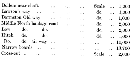
It will be seen that the current was divided into two main splits at the junction of the Hitch North air way with the Narrow Board haulage road. One current, assisted by scales on the various branch haulage roads, ventilated all the pillar workings to the north of the main haulage road; the other, assisted by similar scales, ventilated the whole workings. Part of these two currents, after meeting in the return air road near the air crossing, out-bye from the Middle North, passed over the next air crossing, and meeting the scale from Barmston abandoned way, and that on Lawson's way haulage road, ventilated the Lawson's district. This air current passed under the main intake at a natural crossing near the troubles, and rejoined the main return air, the whole ascending a staple at the troubles to the east of the shafts, and passing to the upcast shaft, crossed the main intake again by a natural crossing near the shafts on its way there.
Gunpowder was not used in working the coal, and only occasionally in stone work.
The Maudlin Seam at Usworth was a moderately fiery seam. Gas was seen in the whole or first workings, and occasionally at the goaf edges; it was not seen on the intake air roads.
The coal was dry and dusty, and the roadways were, with exceptions to be noted, dry and dusty.
The barometer, at the time of the explosion, was standing at 29.90 inches.
The workmen of the colliery had, under General Rule 80 of the Coal Mines Act, last examined the workings of the district of the explosion in July of the year preceding the explosion, and their report was satisfactory, no gas being mentioned as observed.
The officials of the colliery, during their examination of the mine on the day of the explosion, had discovered no unusual source of danger.
The working faces of the district of the explosion were occupied by three shifts of hewers :—

From 5 p.m. to 1 a.m. the pit was occupied by a shift of repairers, stonemen, anti a few hewers; the explosion took place when these men only were in the pit: the night-shift hewers were on the surface and on the point of descending. Had the explosion occurred after these men had descended, the loss of life would have been much greater than it was.
About 600 tons of coal per day was raised from the plane of the explosion.
The Maudlin Seam in the district of the explosion has the following section :—
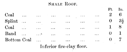
The part down to the 1 foot 8-inch coal only is worked, the band and bottom coal was taken up to make height on all the horse roads.
Clanny, Davy, and Stephenson safety lamps were used.
Damage done to the coal-drawing shaft near the plane of the explosion prevented access to the mine for some time by this shaft, but explorers descended within an hour or two by means of a kibble in the smaller downcast. A large fall near the shafts barred further progress for more than a day; an attempt to reach the workings beyond the fall by the return air way, which was quite open, resulted in the loss of two lives by after-damp. A passage over the fall having been opened, exploration was carried on until the Middle North way was reached, when the passage over the fall near the shafts appeared likely to close, owing to further movement of the stone, and operations were suspended in-bye of this place until it was made secure. This was done on the 7th March, and a party of explorers passed in-bye to the point which had been previously reached, and found the intake full of smoke. This, indicating a fire somewhere ahead, caused the withdrawal of the explorers and the erection of a stopping in the intake, at a point marked A on Plan 1, where only two roads existed, as shown on the plan. A stopping was shortly afterwards erected in the return air road as well. About the 13th March the stopping in the intake was removed, and by bratticing this road the explorers proceeded to the Middle North way and recovered the bodies there. Operations were then resumed on the main road; but a rapid rise, of temperature, as the explorers went on, led to a second withdrawal of the workmen, and the building, in the intake, of a stopping, at the point B, on Plan 1. Exploration was then continued by means of a travelling way between the Middle and Low North haulage roads, until the latter road was reached, and the main intake near it examined and found cool and free from any appearance of fire; a stopping was then built at the point C, Plan 1, and side stoppings erected in all the places leading from the main intake, between B and C, isolated the fire. Exploration was then carried on without any further interruption except that arising from the large falls of roof, and the last body was brought to the surface on the 16th April.
The following indications of the force and direction of the explosion were observed. The numbers on Plan 2, and on the illustrations in the text, refer to the same observations. Want of space has prevented the marking of some of the observations, shown on the sketches, on Plan 2 :—
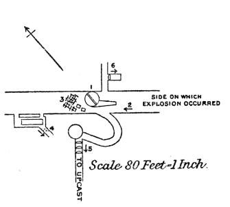 (1) The wood brattice and cage guides in the downcast and coal drawing shaft, were broken and disarranged for 10 yards above the plane of explosion. Some damage was done in this shaft for about the same distance below the plane of explosion. At the moment of the explosion some men in the cage at the surface, who were about to descend the shaft, observed a heavy gust of air laden with dust ascend the pit. Lights near the pit top were extinguished. A man working in the Hutton Seam level, 20 yards below the plane of explosion, and 9 yards of the shaft, was blown over but not seriously injured. No damage was observed in the Hutton Seam level.
At (2) tubs laden with coal were blown past the drawing shaft about 10 yards. At (3) timber was blown out or knocked out by tubs striking it and thus caused a fall of stone. At (4) a stopping above the fine from a multitubular boiler was blown out towards the return, The coal net this flue was found to be on fire after the explosion. The fire had been burning for some time before the explosion, and did not appear to have been caused by the explosion or have any connection with it. The boiler was not injured. The gauge glass was not broken. A paraffin lamp hanging against the wall at the fire hole end was not disturbed and a glass globe on it was not broken. About 150 yards from the downcast and drawing shaft, and in an abandoned way, were two regulating doors, shown on Plan 1. The door nearest the shaft was blown down but not broken; the second door, within a few yards of the other, was not moved.
The force of the explosion appears to have died out within a few yards of the shaft. Between the shaft and the door blown down, was a pile of loose timber undisturbed, and timber set in the road was not moved.





 Contains public sector information licensed under the

