


 |

|

|

|
|
 |
 |
|||

August, 1960
Stainton Quarry — Part 1
A description is given of the limestone quarrying operations carried out by Barrow Quarries Limited at their properties at Stainton-in-Furness, Lancashire. in this first part, details are given of the geology of the Low Furness district, quarry face methods and haulage
By E. G. Holland
Barrow Quarries Limited, a subsidiary of the Barrow Haematite Steel Co. Ltd., operate their Crown and Devonshire Quarries at Stainton-in-Furness. The village of Stainton is situated some four miles to the north-east of the industrial seaport town of Barrow-in-Furness.
No records exist to show when quarrying first began in this area. Of the two quarries the Devonshire Quarry is the older and originally produced limestone blocks for building and monumental purposes. Fossiliferous stone was extensively used for ornamental work, the rock being capable of accepting a fine polish. During the 19th century there was a considerable demand for the stone which was known as Ulverston Marble. However markets for the stone declined rapidly during the early part of this century and no stone is now quarried for this purpose.
The Crown Quarry was started during 1866 when a branch line was constructed (during the early years of the Furness Railway) for the transport of the limestone which was in considerable demand at the blast-furnaces working in Barrow. This branch line, which has gradients of up to 1 in 12, was constructed for a length of 1 mile 56 chains (at a cost of £50,000) and was eventually extended into the Devonshire Quarry when that property was acquired by the present company. A siding and depot for public goods was included at Stainton. Traffic of this nature, however, has been non-existent for a long time and the service was officially withdrawn during 1959. In its first year the branch line carried some 65,000 tons of stone, but by 1919 the annual tonnage had increased to 115,000 tons. The total output of the quarries at present is in the region of 156,000 tons per year, though much of this is now transported by road.
The present company also operated iron ore mines in the vicinity, the ore being carried by rail. Ore was also brought by aerial ropeway from another mine (closed during 1947) and this was discharged into rail wagons at a point close to the old Crown Quarry offices.
Prior to 1941 all of the work involving rock winning, including drilling, breaking and loading was carried out by hand, and this required a large labour force. By 1942 the Devonshire Quarry was mechanised and a modern stone treatment plant installed. The Crown Quarry was then closed.
Until recent years the two quarries were regarded locally as two separate entities. Development work over the past few years has now, however, resulted in the two becoming connected.
Geology
Although geographically a part of the land mass of Cumberland, the Furness Peninsula is administratively in Lancashire. It has water boundaries on all sides except for a short stretch in the extreme north. The peninsula is divided into Plain or Low Furness in the south and High Furness or Furness Fells-the hilly region north, east and west of Coniston Water.
The rocks of the area include members of the Ordovician and Silurian systems-Lower Carboniferous, New Red Sandstones, Pleistocene and Recent formations. The boundaries of these rocks are shown on the simplified geological map of Low Furness seen in Fig. 5. Numerous faults and the location of iron ore deposits, which are confined to the Lower Carboniferous Rocks and glacial debris coverages, are, however, omitted for simplification.
The Ordovician rocks brought to the surface by folding, near Askam, consist of volcanic agglomerates, ashes and andesites with them is associated a highly fossiliferous limestone, Coniston Limestone.
The Silurian Rocks consist of shales, hardened mudstones, slates and gritty sandstones. They form part of the northern boundary of the Carboniferous rocks.
Rocks of the Lower Carboniferous Series can be divided into three groups: 1, Basement Beds; 2, Carboniferous Limestone and 3, Yordales. The second division may be further subdivided into five easily recognisable rock groups. This division was originally carried out on lithological grounds although it has since been proved possible to correlate it with a palaeontological classification.
Of these subdivisions the Urswick Limestone is the one quarried at Stainton. It is a white or creamy well-bedded limestone, some posts being oolitic and some "spotted pseudobreccia." There are thin shale partings between posts, and joints are broadly spaced. This limestone usually weathers to form "grikes" and these are exposed at Urswick, Baycliffe Haggs and Birkrigg Common. This limestone forms part of the floor of Leven Estuary, on the east, and it is exposed there as Chapel Island, The Urswick Limestone is between 375 ft. and 400 ft. in thickness.
A borehole was put down at Stainton to a depth of 940 ft. in limestone, while a borehole at Park near Askam on the west proved 1,190 ft. 8 in. of the rock. It was this belt of limestone which proved to be of prime importance in the development of the Furness Peninsula for it contained pockets of hematite ore, the exploitation of which was directly responsible for the rise of Barrow-in-Furness during the 19th century.
The ore deposits were of metasomatic origin and consisted of "sops," veins and fiats. The largest of the sops was found at Park (near Askam) and this was 1,400 ft. long, from 300 ft. to 600 ft. wide and 600 ft. deep. Sops of all sizes up to this were found.
Extensive north-west, south-east faulting has occurred throughout the area and many of the faults were found to carry ore deposits, especially in mid-Furness where they were linked with east-west faults. At Stainton Quarries, although numerous such ore bodies were worked around the quarries, only in one instance was a workable deposit cut into by quarrying operations. Other, minor veins have from time to time been encountered, however, and although staining was always quite intense on the rock face this was never found to have penetrated to any depth.*
The southern boundary of the limestone is composed of Permian-Triassic rocks, chiefly the New Red Sandstone which is also known as the St. Bees Sandstone. Shown to possess a thickness of 2,080 ft. below Barrow, this rock covers most of the southern part of Low Furness. The base of this series consists of a yellow dolomitic limestone which passes into a thick bed of gypsum below Barrow. Beds of St. Bees Shale, gypsum and annhydrite follow in upward succession to the base of the sandstone in the southern area to a thickness of 600 ft.
Walney Island is underlain by gypsiferous marls with thick lenticular salt beds belonging to the Keuper. These beds are separated from the mainland by a major fault continuing the course of the South Cumberland Boundary Fault.
Most of Low Furness is covered with glacial debris. This drift is composed of a matrix of clay or fine debris containing rounded boulders of all sizes and types, often striated and frequently containing smaller angular fragments of various rocks. The boulder clays are again overlain in some places by sands and gravels roughly stratified. Central and eastern areas of Low Furness are strikingly drumlinised with these materials, with thicknesses up to 180 ft., although the average is, of course, much less. It has been shown by numerous borings that the surface of the buried rocks possess a topography strikingly different from that of the present surface.
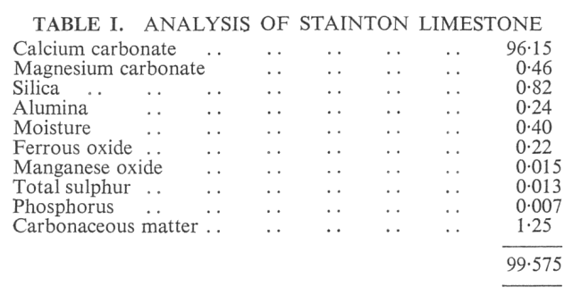
A recent analysis of Stainton limestone is given in Table I.
Overburden
The Quarries Act requires that overburden at Stainton Quarries be cleared back from the working face for at least 15 ft. The overburden varies in thickness from a few inches to 15 ft. and consists of boulder clay and soil containing rocks of all sizes and types.
It is loaded into lorries by a 19-RB, manufactured by Ruston Bucyrus Limited of Lincoln, and powered by a four-cylinder 80 b.h.p. diesel engine. The material is then transported several hundred feet to the waste tip in the northern end of the old Crown Quarry. The 19-RB when not required for overburden stripping is generally employed at one of the stockpiles in the Devonshire Quarry.
Rocks too large to be handled by this face shovel are broken using Polar Ammon Gelignite in 2 oz. cartridges. These are inserted in 1 in. boreholes and initiated by No. 6 detonators and safety fuses. Limestone boulders are usually left alone, but if they are of too large a size for the primary crusher they are blasted in a similar manner.
This area has been the site of pre-historic dwelling sites, and stone celts, saddle querns and various other "finds" have been discovered from time to time.
* The author has dealt more fully with these ore deposits, in his recent book "Underground in Furness." Published by the Dalesman Publishing Company, Clapham via Lancaster.
Drawings and Photographs accompanying the article


Article reproduced from a copy of the magazine held at National Mining Museum Scotland, Newtongrange, Midlothian.




 Contains public sector information licensed under the

