


| Newspaper Articles |

|
Newspaper Articles |
 |
 |
16th November 1940, Page: 145, Column: 1
Notes On Surveyors' Examination
Central Examiner's Report
The written examination for mine surveyors' certificates was held on 4th July, 1940, and the oral and practical examination of candidates who obtained qualifying marks thereat was carried out during the week commencing 12th August, 1940. The undernoted table shows the number of candidates who presented themselves for examination at each centre, and the number who alternatively qualified for a certificate :—
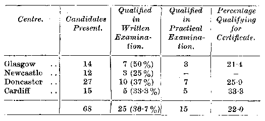
The percentage of candidates who qualified for a certificate shows a decrease when compared with recent examinations, and for that the poor showing in the oral and practical tests by candidates at the Glasgow and Newcastle centres is the prime cause. The percentage of failures in this part of the examination was higher than for some time past. Reports from the examiners indicate a fair measure of accuracy in theodolite work, but there is almost general adverse criticism of the instrumental manipulation, which in many instances is stated to have been slow and hesitant. Several examiners also comment upon unsatisfactory methods of measuring vertical angles.
Work with the level was generally satisfactory, but methods of measuring are severely criticised by several examiners:
In the office test, draughtsmanship was fairly satisfactory as a rule, but answers to the several questions submitted in the oral test were frequently far from what might reasonably have been anticipated, and indicated a lack of experience and confidence
The work done in the written part of the examination was in general fairly satisfactory, and while the percentage qualifying in that part did not touch the record figure of November last year, it was well up to the average of recent satisfactory performances.
Reviewing the answers as a whole it falls to be stated that candidates still show definite weakness in tackling questions outwith the sphere of their daily routine — a feature to which attention has previously been directed on many occasions.
Below we give the text of the questions set at the examination, each question being followed by the comment of the examiner on the general work of the candidates. The comments are in italics. Plans not reproduced. The official pamphlet containing the Question Papers (price 1s. 6d. net) is obtainable through H.M. Stationery Office.
Morning Session.
(1) Compulsory Question. — Plan . . . shows surface contour lines at vertical intervals of 50 feet, and a small area of workings in a certain seam which have been carried forward to a fault of unknown displacement. It also shows the sites of three bores which have proved the seam in the area to the south of the fault at the depths indicated. Draw on the plan the line of outcrop of the seam on each side of the fault, and also the barren area in the seam due to the fault. Thereafter mark on the plan the approximate vertical displacement of the fault at the point where it underlies the 400 feet contour line. Assume that a thickness of 20 feet of alluvium overlies the rockhead, and that the angle of the fault plane is 40 degrees from the vertical. (14)
Less than one-third of the answers were satisfactory or reasonably so. The extent of the barren area was rarely correctly indicated, and there was a surprising lack of ability to determine accurately from the three bores the direction and rate of full dip of the seam.
(2) A concrete settling tank forming part of the washery plant at a colliery has been found to be subsiding. The structure, which is 60 feet in height and 50 feet in diameter at the top, is shaped in the form of the frustum of an inverted cone seated on an octagonal-shaped base, with sides each measuring 10 feet. One of the sides faces due North. Precise levels taken over a period at reference marks near ground level on each corner of the octagonal base — commencing at the eastern end of the side facing North, and moving in a clockwise direction — show the respective total subsidence to be as follows : (1) 4.9 inches, (2) 7.2 inches, (3) 8.4 inches, (4) 7.8 inches, (5) 5.7 inches, (6) 3.4 inches, (7) 2.2 inches, (8) 2.8 inches. Calculate the direction in which the structure is leaning, and its angle of deviation from the vertical. (12)
Comparatively few candidates attempted this by no means difficult question, and still fewer obtained a correct solution.
(3) Plan . . . has been enlarged from a 1/2500 Ordnance Survey Map, and shows a debris heap, the material in which is about to be excavated for brickmaking purposes. You are asked to visit the ground and carry out such work as will enable you to make an estimate of the quantity of material contained in the heap. Describe fully the work which you would carry out in the field — using the plan if necessary — and in the drawing office, in order that the tonnage of debris in the heap may be ascertained with the maximum of accuracy. (The spot levels shown on the plan are given solely for the purpose of indicating the approximate height of the heap, and are not to be made use of for any part of the work.) (10)
Answers generally were disappointing, and it would appear as if many candidates have had no practical experience in this class of work.
(4) You are asked to carry out an important and fairly lengthy underground traverse with a 5-inch theodolite which you have neither previously seen nor had an opportunity of using. The instrument is not new, but is believed to have been used with reasonable care. Describe clearly and concisely what you would do with the instrument before commencing the traverse. (8)
Answers generally were satisfactory.
(5) With the object of ascertaining the height of a chimney stack, an angle of elevation was taken to its top from a point due South thereof and found to be 58°42'. From another point 255 feet due West of the above point another angle of elevation to the top was taken and found to be 28°12'. What is the height of the chimney ? (8)
Roughly 30 per cent. of the answers were correct. The remainder were generally entirely wrong.
(6) Place the undernoted in correct descending geological sequence: Cambrian, Carboniferous, Devonian, Ordovician, Permian, Silurian, Tertiary, and Triassic. State what you understand is meant by the undernoted geological terms : (a) Concealed outcrop ; (b) Drift; (c) Unconformity. (8)
This question was not often attempted. Candidates at Cardiff centre obtained more entirely correct answers than all the other centres together.
Afternoon Session.
(1) Compulsory Question. — Two traverse stations A and B are situated in an upper and lower seam, respectively. Their co-ordinates and height above datum, in feet, are respectively as follow :—

The following are the notes of a theodolite traverse made from station B :—
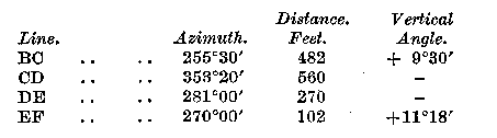
From station A a level cross-measures drift with azimuth 90° has been driven for a distance of 720 feet to another station G. It is proposed to continue AG in the same direction — but at a gradient rising at 1 in 10 — until the face has reached a point X, 234 feet from G, at which it is to be connected by a level cross-measures drift With EF produced in the direction and at the gradient stated in the traverse notes. Calculate the azimuth and length of the level cross-measures drift. (14)
This compulsory question was generally well answered. There were, however, an unusually large number of errors made in calculating the co-ordinates of the several stations.
(2) A colliery leasehold contains two seams which are 80 yards apart, measured at right angles to the plane of stratification. The strata dip at 6 inches to the yard in the direction due North. The sketch . . . (not drawn to scale) shows a heading AB advancing direct to the dip, and two parallel levels, 300 feet apart, driven to the line of strike, in the lower seam. It is proposed to drive a cross-measures drift from C rising at 6 inches to the yard in the direction CD, and another from E rising at 12 inches to the yard in the direction EF, both of which are to intersect the upper seam. Calculate the azimuth and gradient of a roadway to be driven between the points at which the upper seam will be intersected by the drifts EF and CD, respectively. (12)
Approximately one-half of the candidates attempted this question, of whom only nine obtained a correct or approximately correct solution.
(3) The plan . . . shows an area of ground with contour lines at vertical intervals of 5 feet. It also shows the centre line AB of a proposed access road to a colliery, which is to be 20 feet in width and to rise uniformly from the point A at a gradient of 1 in 20. The formation level of the roadway at A is 110, and the slopes are to batter at 2 horizontal to 1 vertical. Show on the plan the position of a fence which is to be erected parallel to and 3 feet distant from the top and/or bottom of the slopes on each side of the finished roadway. Thereafter calculate approximately the area of ground enclosed within the fences between the 100 feet and 145 feet contour lines. (12)
A fair number of excellent answers. In general, however, much time was needlessly wasted in calculating the area enclosed by the fences in consequence of failure to select the simplest method of doing so.
(4) Two underground roadways AB and HG whose azimuths are respectively 202°46' and 231°36' are about to be connected at the points B and G by a curve of 76 feet radius. The coordinates, in feet, of the points A and H are as follows :—
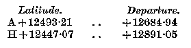
Make the necessary calculations to enable five equal chords BC, CD, DE, EF, and FG to be set out. State the length of the chord, the angles between them, and also the distances AB and HG to the beginning and end of the curve, respectively. (10)
Answers were no better than moderate, only one-third of them being correct or approximately so.
(5) Part of the surface of a colliery leasehold is occupied by a number of residential houses of considerable value, and workings in a coal seam, 4 feet in thickness and 580 yards in depth, are about to be carried forward under them. You are asked to keep an accurate record of the subsequent movement of the surface arising from that working. State clearly how you would do so in order that the resultant movement of each individual property may be determined from time to time with the maximum of accuracy. (8)
Answers generally were satisfactory. A few candidates gave the stereotyped answer of putting in pegs at 100 feet intervals and taking periodic levels thereon — a method quite unsuitable for ascertaining subsidence of individual properties.
(6) A new heading in a certain seam is about to be set away on a bearing of N49°W in the immediate vicinity of steel arches, and you are asked to erect thereat a temporary set of direction lines, for which operation only a dial without vernier attachment is available. About 500 feet from the position of the new heading there is an airway in which a "free bearing" can be obtained. State fully how you would carry out the work, assuming five settings of the instrument to be necessary between the airway and the new heading. Your answer must be illustrated by a sketch. (8)
Few satisfactory or reasonably satisfactory answers. Generally the sketches were poor and rarely gave definite indication of what was stated in the written part of the answer.
(7) A new shaft, 21 feet in diameter, is about to be sunk to a depth of 640 yards, and you are to be held responsible for the maintenance of the centre line in strict verticality. Describe the method which you would adopt to obtain the desired result, and illustrate your answer by a sketch. (8)
Answers generally were disappointing, and it was clear that comparatively few candidates were acquainted with modern methods of obtaining the result asked for.
 |
 |
| Related Articles | |
|
|
| Pub. Date | Article (Newspaper) |
|---|---|
| 27 Jan 1940 | Board for Mining Examinations (The Science and Art of Mining) |
| 23 Mar 1940 | Board For Mining Examinations (The Science and Art of Mining) |
| 05 Oct 1940 | Examination Results (The Science and Art of Mining) |
| 16 Nov 1940 | Notes On Surveyors' Examination, Central Examiner's Report (The Science and Art of Mining) |
| 30 Nov 1940 | Notes On Managers' Examinations. — I, Report of Central Examiners (The Science and Art of Mining) |
| 14 Dec 1940 | Notes On Managers' Examinations — II, Comments on Work of Candidates (The Science and Art of Mining) |
| 27 Dec 1941 | Mining Examinations 1940 Report (The Science and Art of Mining) |



 Contains public sector information licensed under the

