


| Newspaper Articles |

|
Newspaper Articles |
 |
 |
25th February 1939, Page: 268, Column: 1
Spitsbergen Coalfield
Mr. Norman Pye, B.A., assistant lecturer in geography at Manchester University, was topographical surveyor with the expedition to Spitsbergen on 1938, organised by the Scott Polar Research Institute. He read a paper on 14th February before the Manchester Geographical Society on "Some Geographical Observations during the Expedition to Billefjorden, Spitsbergen," in which he said that in the Ice Fjord region there is a fairly complete stratigraphical sequence from Devonian through Carboniferous with coal measures, permo-Carboniferous limestones, Triassic, Jurassic, Cretaceous, and finally Tertiary rocks, and in four of these systems — Devonian, Carboniferous, Cretaceous and Tertiary — coal deposits are found. These beds have a gentle dip to the south-west, and this is responsible for the outcropping of the crystalline complex to the north and the location of the Tertiary coalfield in the great shallow syncline to the south of Ice Fjord. This field has first-class reserves of close shiny coal of high heating power, and is the scene of operations of the only two mining companies in Spitsbergen — the Store Norske Spitsbergen Kulkompagni at Longyear City and the Russian at Green Harbour. The conditions of mining and exporting the coal from Longyear City contrast strongly with those familiar to us in this county. The seam, 3 feet to 4 feet thick, is located less than a mile from deep water anchorage. It is worked at a height of about 1,000 feet by a level adit, and being free from dirt the coal is taken by a wire ropeway straight from the mine across Longyear Valley to the store heap at the coaling wharf. Mining is continuous all the year round, but export of coal is limited to the summer season. Devonian coal is found in one locality — Mimes Valley on the west side of Billefjorden — and only one thin seam of Cretaceous coal is known. The Carboniferous deposits are best known in the inner branches of Ice Fjord round the head of Billefjorden and in the territory between this and Temple Fjord. The greater part of these Carboniferous areas was claimed by the Scottish Spitsbergen Syndicate which prospected but did not mine its estates in 1919. The region between Billefjorden and Gips Valley is part of the central block faulted region of unfolded rocks with a dip of about 3° to the south-west. In the whole of this region the north-east to south-west valleys are most striking features and are certainly related to faulting.
The mountains on the east side of Billefjorden have a characteristic aspect owing mainly to the stratigraphical succession of the Carboniferous rocks of which they are composed.
The general succession in the Campbells-Gips Valley region is :—
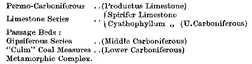
Within the Campbell Range and the mountains round the head of Gips Valley the solid geology is exclusively Carboniferous, but the dip within these ranges results in the coal-bearing beds of the CuIm (sandstone shale and coal seam) being brought up from under the Gypsiferous series near the River Gerrit and near the Methuen Glacier. The Gypsiferous series consists of over 400 feet of alternating bands of limestone, mudstone and gypsum.
 |
 |
| Names mentioned in this article | |
 |
 |
| Name | Age | Occupation | Notes |
|---|---|---|---|
| Pye, Norman | Assistant Lecturer |




 Contains public sector information licensed under the

