


 |

|

|

|
|
 |
 |
|||
February, 1959
Mining in Great Britain and Ireland
J. M. Caw, A.C.S.M., A.M.I.M.M., continues his summary of the papers that were discussed at a symposium held in London last September on the future of non-ferrous mining in Great Britain and Ireland. This section* covers those papers dealing with ore deposits in northern England, the Midlands and Wales
In a paper (VII) entitled Non-Ferrous Mining Potentialities of the Northern Pennines, K. C. Dunham, F.R.S., M.I.M.M., reviews the geology, mode of mineral occurrence, history arid recent progress in the Northern Pennine orefield, an area of 1,500 sq. miles covering part of Durham, Northumberland, Cumberland, Westmorland and Yorkshire.
Mining has been known on this orefield since Roman times and the recorded output since the 17th century exceeds 3,200,000 tons of lead concentrates, about 270,000 tons of zinc concentrates, 930,000 tons of fluorite, 910,000 tons of barytes and 775,000 tons of witherite.
The area discussed and shown in Fig. 8 is divided into the Alston and Askrigg blocks by the Cotherstone syncline. For the most part the orefield occupies high moorland country with extensive tracts above 1,500 ft. O.D. and with many of the watersheds within the dales exceeding 2,000 ft. O.D. Electrical grid service is available in the main valleys. Geological survey maps covering the area at a 6 in. scale and showing vein and rock outcrops have either been published or are available in manuscript at the library of the Geological Survey Museum. The most recent comprehensive work on the Alston block is a geological survey memoir by Dunham** (1948) and a corresponding volume on the Askrigg block is being prepared. There are also accounts of the barytes and witherite mines (Dunham and Dines, 1945) and the fluorspar workings (Dunham, 1952) of the whole field.
Geology
The Northern Pennines are formed of flat-lying or gently inclined sediments of the Lower Carboniferous and lower third of the Upper Carboniferous having a total thickness of 2,000 to 3,000 ft. The orefield is outlined to the north, south and west by faults, while to the east the rocks of the Alston block disappear beneath the Durham Coal Measures which are in turn overlain by Permian strata. South of the Cotherstone syncline Coal Measures are no longer present and the Permian rests on Millstone Grit or lower horizons. Economic mineralisation occurs at several localities in the Durham Coalfield and traces of mineralisation are known in the Permian.
Average stratigraphical sections of the Carboniferous rocks on the Alston and Askrigg blocks are shown in Fig. 10. In descending order the Permian Magnesian Limestone reaches about 600 ft. where it is exposed in East Durham. No workable concentrations of non-ferrous minerals occur in it but in South Durham and northwest Yorkshire beds of halite and anhydrite occur with potassium salts beneath Eskdale. The lowest Permian beds rest unconformably on the Carboniferous rocks. The Coal Measures comprise alternations of sandstones, fireclays, coals, thin sandstones and shales, with some 14 workable coal seams being found. The Millstone Grit consists of coarse and fine grained sandstones individually up to 75 ft. thick with silicified tops and at least three intercalated shale formations. in West Durham the total thickness is 300 to 350 ft., but this increases towards the south.
The Upper Limestone Group comprises beds of Yoredale facies lying between the base of the Millstone Grit and the base of the Great or Main Limestone. It consists of thin limestones, cherts or marine bands, coals, shales, sandy shales and sandstones.
The Middle Limestone Group shows the rhythmic development of beds of the Yoredale facies and the sequence of limestone — calcareous shale — non-marine shale — sandy shale — sandstones — gannister — coal is repeated, with local omissions, Il times. The limestones persist over a wide area but are seldom over 30 ft. thick with sandstones rarely over 50 ft. thick.
The Lower Limestone Group is dominated by limestone but three cyclotherms with shale and sandstone which are present on the Alston block pass southwards into limestone 450 ft. thick in the Askrigg block. The Basement Group consists in the northern part of the orefield of a highly variable series of sandstones, shales, impure limestones and conglomerates ranging in thickness from 140 to 1,100 ft. in thickness. The limestones in this group are only important as ore horizons in the extreme south-east of the orefield.
Igneous rocks have been indicated at depths of 5,000 ft. by recent gravity surveys. Exposed rocks include the Whin Sill quartz dolerites and a related set of ENE dykes in the Alston block. The sills belong to a single epoch before mineralisation occurred and may result in metamorphism up to 60 ft. above the sill-roof which is important where induration of soft shales has resulted.
The geometrical pattern of ENE, WNW and NNE mineral veins to be seen was probably developed in early Permian times. The vein fissures are normal faults, sometimes accompanied by shear folds. Their displacements are usually of the order of I to 20 ft., but a few faults of displacement up to 140 ft. are mineralised. An important feature of vein fissures of small displacement is the fact that where they cross hard, brittle strata they are steep and often clear of gouge, while on entering shale the dip greatly increases and the fracture is closed. The profound effect of this refraction upon the oreshoots will be obvious from Fig. 12.
Controls of mineralisation
The author summarises the main controls as follows :—
(1) The directions of fracture most favourable to mineralisation are east-northeast and west-northwest.
(2) The refraction effect illustrated in Fig. 12 which often results in ribbons of ore 4,000 ft. long and 60 ft. high.
(3) Oreshoots tend to terminate or originate at north-northwest cross fractures; thus one vein may carry several oreshoots separated laterally by barren ground bounded by cross-veins.
(4) The Great or Main Limestone has yielded 75 per cent. of the ore mined indicating an active circulation of mineralising fluids at this horizon.
(5) Other hard beds may be mineralised giving a number of deposits separated by soft beds.
(6) A lateral zonal arrangement of minerals can be observed. Good fluorite is found in the inner zone with a little copper grading to good sulphide-free barytes and witherite at the outer periphery of the outer zone. The maximum deposition of lead and zinc occurs between the two zones.
(7) Where a similar vertical zoning exists fluorite gives place upwards to barytes and downwards to quartz — marcasite — pyrrhotite — chalcopyrite.
(8) In certain limestones metasomatism has produced valuable replacement "flats" always related to a feeding vein or fissure. A very favourable level for fiats lies 4 ft. below the shaly upper part of the Great Limestone, about 40 ft. above its base.
(9) The condition for the formation of metasomatic deposits in limestone is probably related to restriction of the flow of fluids by, say, an impervious shale bed. Flats do not occur where sandstone rests on limestone.
(10) A closely-spaced complex of fractures favours replacement but tends to produce wide vertical oreshoots. The fractures may be completely barren in shale above or below.
(11) The usual alterations are observed in the oxidation zone; there is no evidence of secondary movement or enrichment of lead, but secondary concentration of zinc silicate or carbonate has been recorded.
History
The Greenhow mines were known to the Romans, and medieval records of mining in this orefield date from the 12th century. However, no extensive mining is believed to have taken place before about 1650, although nearly all the known veins in Weardale had been found by that date. The London Lead Company and family concerns operated from the end of the 17th century, the heyday of Northern Pennine lead mining being the 19th century when .a number of long adit levels were driven for drainage and exploration; two of these were 20,090 ft. and 24,725 ft. in length. For the period 1818-1876 some 626,626 ft. of development were necessary to produce 388,394 tons of lead concentrate. Although by 1905 the activities of the London Lead Company had ceased, nevertheless a number of companies have continued work to the present day.
Since 1880, fluorite and barium minerals have become increasingly important, one fluorspar and two barytes producers having exceeded an output of 200,000 tons, In the fluorite zone of the Alston block, 14 mines have been active between 1945 and 1958. Those with a notable total production to date are:—
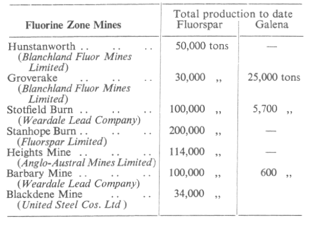
A number of mines still contain fluorspar left in the old stopes as unwanted when the lead was removed.
No systematic mining has been undertaken within the fluorite zone of the Askrigg block though some fluorspar has been obtained from dump material.
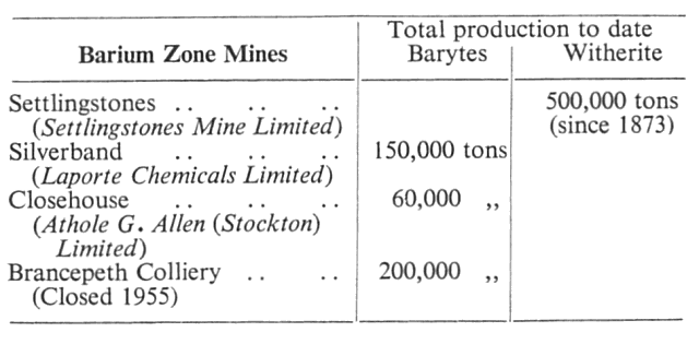
In the barium zone of the Alston and Askrigg blocks the total recorded barium production from currently producing mines is as follows :—
Future possibilities
A study of the distribution of known oreshoots in space, in relation to stratigraphy and mineral zoning, suggests that many orebodies remain undiscovered and there is clearly a case for prospecting those areas in which favourable horizons such as the Great Limestones lie concealed by younger rock formations. The Whin Sill also invites consideration.
The author goes on to consider a number of specific areas classified as, firstly, watershed areas and, secondly, valley areas. The former generally require the driving of long tunnels and the latter deep sinking. Reworking old mines for fluorspar or lower-grade lead than was originally mined, and the possibility of concealed barium deposits in the Durham coalfield also receives attention.
* The first part of this article appeared on pp. 22-30, of our January, 1959, issue, and was concerned with papers relating to Scotland and Ireland.
** K. C. Dunham, "Geology of the Northern Pennine Orefield," Mem. Geol. Surv. U.K., 1948, H.M.S.O.
Drawings and Photographs accompanying the article


Article reproduced from a copy of the magazine held at National Mining Museum Scotland, Newtongrange, Midlothian.




 Contains public sector information licensed under the

