


| Borings |

|
Index |

|
Borings |
 |
 |
|||
| An Account of the Strata of Northumberland and Durham | Volume: SUP, Page: 138 |
No. 2,547 — Coatyards
Township of Coatyards, Northumberland
Sheet 53 of 19thC Ordnance Map. Lat. 55° 14' 27½", Long. 1° 52' 09".
[ OS Grid Ref: NZ 08318 94114 (408318,594114) ]
Account of Strata passed through in a Bore-hole put down near Coatyards Farm on the North Side of the Road leading to it and due South of the Pits, 1903
Approximate surface level 730 feet above sea (Ordnance datum)
 Larger image of entry
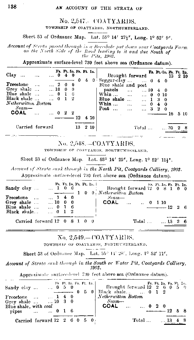
| Source: | An Account of the strata of Northumberland & Durham as proved by Borings & Sinkings, Supplement, published by the North of England Institute of Mining & Mechanical Engineers, 1910 |
Nearby Borings
Additional Links
| | A graphical representation of this entry |
| 19th Century Mapping | |
| | List of other entries on Northumberland Sheet 53 |
 | Location on 1st Series OS Map [www.old-maps.co.uk] |
| 20th Century Mapping | |
| | List of other entries on Landranger Sheet 81 (Alnwick & Morpeth, Rothbury & Amble) |
| | List of other entries on Detail Sheet NZ09 |
| | Location on current map [www.streetmap.co.uk] |
 |
||
 |
 |
 |




 Contains public sector information licensed under the

