


| Borings |

|
Index |

|
Borings |
 |
 |
|||
| An Account of the Strata of Northumberland and Durham | Volume: SUP, Page: 111 |
No. 2,508 — Carr Edge
Township of Newbrough, Northumberland
Sheet 84 of 19thC Ordnance Map. Lat. 55° 01' 20", Long. 2° 11' 15".
[ OS Grid Ref: NY 88014 69766 (388014,569766) ]
Account of Strata sunk through in the East Shaft, Carr Edge Mine, in the second field East of Meg's House
Approximate surface level 520 feet above sea (Ordnance datum)
 Larger image of entry
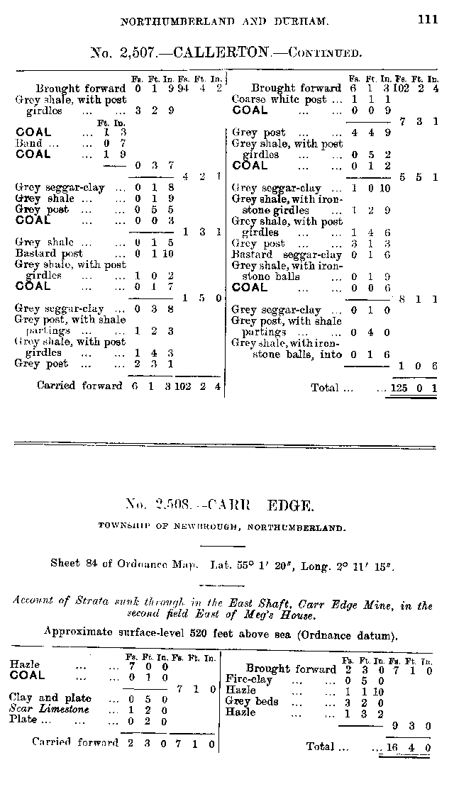
| Source: | An Account of the strata of Northumberland & Durham as proved by Borings & Sinkings, Supplement, published by the North of England Institute of Mining & Mechanical Engineers, 1910 |
Nearby Borings
Additional Links
| | A graphical representation of this entry |
| 19th Century Mapping | |
| | List of other entries on Northumberland Sheet 84 |
 | Location on 1st Series OS Map [www.old-maps.co.uk] |
| 20th Century Mapping | |
| | List of other entries on Landranger Sheet 87 (Hexham & Haltwhistle) |
| | List of other entries on Detail Sheet NY86 |
| | List of other entries on Outdoor Leisure Sheet 43 (Hadrian's Wall) |
| | Location on current map [www.streetmap.co.uk] |
 |
||
 |
 |
 |




 Contains public sector information licensed under the

