


| Borings |

|
Index |

|
Borings |
 |
 |
|||
| An Account of the Strata of Northumberland and Durham | Volume: L-R, Page: 242 |
No. 1,528 — Penshaw
Township of Painshaw, Durham
Sheet 13 of 19thC Ordnance Map. Lat. 54° 52' 26", Long. 1° 29' 50".
[ OS Grid Ref: NZ 32259 53361 (432259,553361) ]
Account of Strata sunk through in the D or Whitfield Pit, Penshaw Colliery. October 30th, 1830
Approximate surface level 170 feet above sea (Ordnance datum)
 Larger image of entry
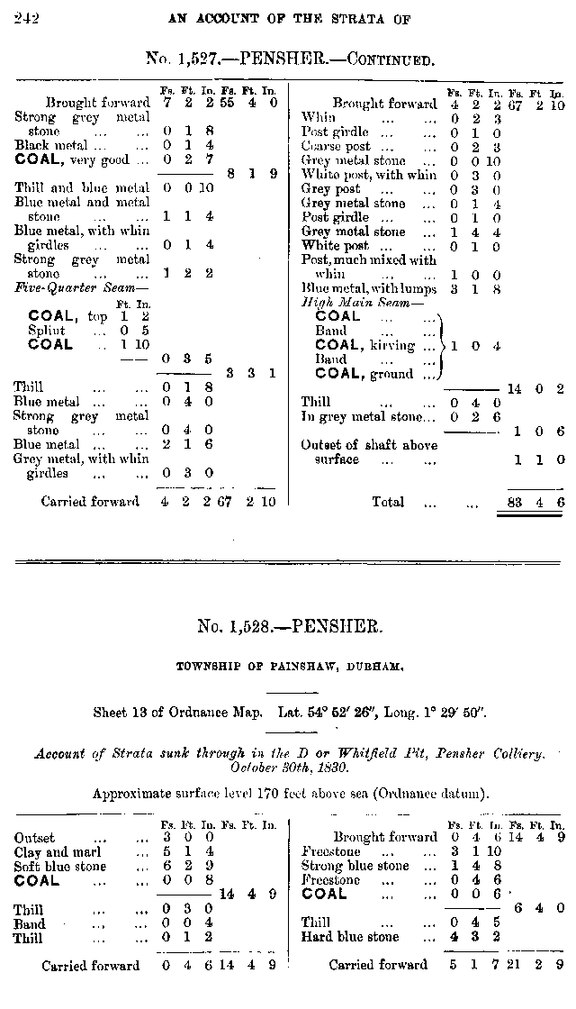
| Source: | An Account of the strata of Northumberland & Durham as proved by Borings & Sinkings, Volume L-R, published by the North of England Institute of Mining & Mechanical Engineers, 1887 |
Nearby Borings
Additional Links
| | A graphical representation of this entry |
| 19th Century Mapping | |
| | List of other entries on Durham Sheet 13 |
 | Location on 1st Series OS Map [www.old-maps.co.uk] |
| 20th Century Mapping | |
| | List of other entries on Landranger Sheet 88 (Newcastle upon Tyne, Durham & Sunderland) |
| | List of other entries on Detail Sheet NZ35 |
| | Location on current map [www.streetmap.co.uk] |
 |
||
 |
 |
 |




 Contains public sector information licensed under the

