Catalogue of Plans of Abandoned Mines for Bebside Colliery
Srce
Year |
|
Plan
No. |
|
Date
Received |
|
|
|
|
R 387A |
|
|
|
BEBSIDE |
| |
Parish: Blyth.
COAL:
Yard.
Mining Record Office Reference: R.3
|
| |
Map: NBL 70.SW (1924)
|
| |
Map: NBL 78.NW (1924)
|
| |
|
|
R 387A |
|
|
|
BEBSIDE |
| |
Parish: Blyth.
COAL:
Hartley.
Mining Record Office Reference: R.3
|
| |
Map: NBL 70.SW (1924)
|
| |
Map: NBL 78.NW (1924)
|
| |
|
|
8,565 |
|
|
|
BEBSIDE, A, B, and C |
| |
Parish: Blyth.
COAL:
High Main.
(Abandoned: Jun 1906).
Mining Record Office Reference: F.7
|
| |
Map: NBL 70.SW (1924)
|
| |
Map: NBL 78.NW (1924)
|
| |
|
|
8,564 |
|
|
|
BEBSIDE |
| |
Parish: Blyth.
COAL:
Plessey.
(Abandoned: 19 Dec 1925).
Mining Record Office Reference: F.7
|
| |
Map: NBL 70.SW (1924)
|
| |
Map: NBL 78.NW (1924)
|
| |
|
|
8,564 |
|
|
|
BEBSIDE |
| |
Parish: Blyth.
COAL:
Stone.
(Abandoned: 19 Dec 1925).
Mining Record Office Reference: F.7
|
| |
Map: NBL 70.SW (1924)
|
| |
Map: NBL 78.NW (1924)
|
| |
|
|
8,564 |
|
|
|
BEBSIDE |
| |
Parish: Blyth.
COAL:
Harvey.
(Abandoned: 19 Dec 1925).
Mining Record Office Reference: F.7
|
| |
Map: NBL 70.SW (1924)
|
| |
Map: NBL 78.NW (1924)
|
| |
|
|
8,564 |
|
|
|
BEBSIDE |
| |
Parish: Blyth.
COAL:
Five Quarter.
(Abandoned: 19 Dec 1925).
Mining Record Office Reference: F.7
|
| |
Map: NBL 78.NW (1924)
|
| |
|
|
8,564 |
|
|
|
BEBSIDE |
| |
Parish: Blyth.
COAL:
Yard.
(Abandoned: 19 Dec 1925).
Mining Record Office Reference: F.7
|
| |
Map: NBL 70.SW (1924)
|
| |
Map: NBL 78.NW (1924)
|
| |
|
|
8,564 |
|
|
|
BEBSIDE |
| |
Parish: Blyth.
COAL:
Low Main.
(Abandoned: 19 Dec 1925).
Mining Record Office Reference: F.7
|
| |
Map: NBL 70.SW (1924)
|
| |
Map: NBL 78.NW (1924)
|
| |
|
|
8,564 |
|
|
|
BEBSIDE |
| |
Parish: Blyth.
COAL:
Bensham.
(Abandoned: 19 Dec 1925).
Mining Record Office Reference: F.7
|
| |
Map: NBL 70.SW (1924)
|
| |
Map: NBL 78.NW (1924)
|
| |
|
|
8,564 |
|
|
|
BEBSIDE |
| |
Parish: Blyth.
COAL:
Main.
(Abandoned: 19 Dec 1925).
Mining Record Office Reference: F.7
|
| |
Map: NBL 70.SW (1924)
|
| |
Map: NBL 78.NW (1924)
|
| |
| 1926 |
|
|
|
1926 |
|
Bebside |
| |
Post Town: Horton.
COAL:
Main Coal, Bensham, Stone Coal, Five Quarter, Plessey, Harvey, Yard, Low Main, High Main.
(Abandoned: 1926).
|
| |
The date of the Ordnance Survey edition used for Official puposes is
given, in brackets, against the number of each map, e.g. DUR 23.NE (1923)
refers to the 1923 edition of Sheet 23 (North East Quarter) for County
Durham.
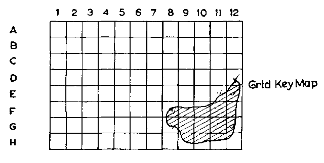
The method of indicating the extent of the workings shown on each plan
is that the Six Inch Scale Quarter Sheets of the Ordnance Survey
(County Series) have been divided into 1½ inch (¼ mile) squares,
lettered vertically A-H and numbered horizontally 1-12, the
approximate position of the workings being indicated by the reference
squares quoted, thus :—
D12; E11,12; F8,9,10,11,12; G8,9,10,11,12; H9,10,11,12
The plans of abandoned mines are held by the Coal Authority
(
https://www.gov.uk/government/organisations/the-coal-authority)
at the following address:
The Coal Authority, 200 Lichfield Lane, Mansfield, Nottinghamshire, NG18 4RG
- 1926 Mines Inspectors Report
- NCB Card Index of Abandoned Mine Plans
 main page for Bebside Colliery









 Contains public sector information licensed under the

